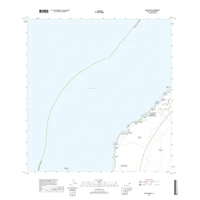
2017 Map of Makalawena
USGS Topo · Published 2017About this map
The Ala Kahakai National Historic Trail traces the shoreline of the Island of Hawai'i, connecting a series of remote coastal features and cultural landmarks. This western coastal landscape is defined by the massive Lava Flow of 1801, which reaches toward the sea north of the Kona International Airport at Keahole. The coastline is punctuated by numerous points and bays, including Kahoiawa Bay and Awakee Bay, alongside distinctive geological markers like Kuilu and the Opaeula Pond. This 2017 survey illustrates the modern intersection of historic conservation and critical infrastructure, showing how modern residential roads like Makani Eka Pl and Alapii Kula Dr have developed near these ancient coastal sites. The map serves as a detailed guide to the diverse shoreline environments from Makalawena Beach to Mahai'ula Beach.
Find a feature on this map
35 named features on this map. Tap any name to fly to it.
Don’t see what you’re looking for? This feature index may not catch every label — zoom into the map to look around manually.
Map Details
Editions of this 2017 Makalawena Map
This is the sole edition of this map. No revisions or reprints were ever made.
Other maps of this area

1928 · Puako
USGS Topo · 1:62,500

1928 · Kailua
USGS Topo · 1:62,500

1954 · Hawaii North
USGS Topo · 1:250,000

1959 · Hawaii North
USGS Topo · 1:250,000

1959 · Kiholo
USGS Topo · 1:24,000
1959 · Anaehoomalu
USGS Topo · 1:24,000

1959 · Makalawena
USGS Topo · 1:24,000

1959 · Keahole Point
USGS Topo · 1:24,000

1959 · Kailua
USGS Topo · 1:24,000

1961 · Hawaii North
USGS Topo · 1:250,000