1978 Map of Malheur Lake
USGS Topo · Published 1997About this map
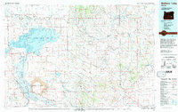
Malheur Lake and the surrounding high desert wetlands dominate this 1978 perspective of Harney and Malheur Counties. The hydrological complexity of the Malheur National Wildlife Refuge is on display, showing the drainage of the Silvies River and the vast marshlands of Diamond Swamp. To the south, the geological character shifts abruptly at Diamond Craters, where extensive lava fields mark the terrain. Small ranching outposts and settlements like New Princeton, Circle Bar, and Venator are connected by a network of valley roads, including the Blitzen Valley Road. The map reveals the precarious balance of water in the Great Basin, tracing numerous intermittent streams and reservoirs such as Dry Lake Reservoir and Barton Lake. This document serves as a detailed record of the region's managed wilderness and isolated ranching communities before modern landscape changes.
Find a feature on this map
53 named features on this map. Tap any name to fly to it.
Don’t see what you’re looking for? This feature index may not catch every label — zoom into the map to look around manually.
Map Details
Editions of this 1978 Malheur Lake Map
This is the sole edition of this map. No revisions or reprints were ever made.
Other maps of this area

1955 · Jordan Valley
USGS Topo · 1:250,000

1955 · Burns
USGS Topo · 1:250,000

1955 · Adel
USGS Topo · 1:250,000

1955 · Boise
USGS Topo · 1:250,000

1957 · Adel
USGS Topo · 1:250,000

1957 · Jordan Valley
USGS Topo · 1:250,000

1958 · Burns
USGS Topo · 1:250,000

1958 · Boise
USGS Topo · 1:250,000

1958 · Adel
USGS Topo · 1:250,000

1958 · Jordan Valley
USGS Topo · 1:250,000