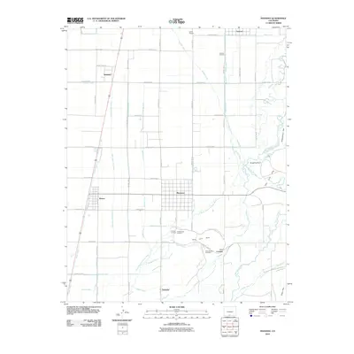
2010 Map of Manassa
USGS Topo · Published 2010About this map
Manassa and its surrounding agricultural basin are defined by an intricate network of irrigation systems and early settlements in this part of Colorado. The landscape is crisscrossed by numerous canals and ditches, including the San Luis Ditch, Romeo Canal, and Ephriam Ditch, which redirect water from the Conejos River and Rio San Antonio to the surrounding fields. This complex hydrography reflects the long history of water management essential for sustaining communities like Romeo, Bountiful, and Sanford. To the east, the terrain rises into the San Luis Hills and Piñon Hills, providing a sharp contrast to the flat valley floor. Local heritage is particularly evident in the cluster of burial grounds near the main town, such as the Old Manassa Cemetery, New Manassa Cemetery, and Soward Cemetery, while smaller locales like Los Cerritos and Espinosa dot the southern reaches.
Find a feature on this map
58 named features on this map. Tap any name to fly to it.
Don’t see what you’re looking for? This feature index may not catch every label — zoom into the map to look around manually.
Map Details
Editions of this 2010 Manassa Map
This is the sole edition of this map. No revisions or reprints were ever made.
Other maps of this area

1922 · Conejos
USGS Topo · 1:125,000

1945 · Durango
USGS Topo · 1:250,000

1953 · Durango
USGS Topo · 1:250,000

1954 · Durango
USGS Topo · 1:250,000

1954 · Trinidad
USGS Topo · 1:250,000

1955 · Trinidad
USGS Topo · 1:250,000

1958 · Trinidad
USGS Topo · 1:250,000

1959 · Trinidad
USGS Topo · 1:250,000

1961 · Durango
USGS Topo · 1:250,000

1963 · Durango
USGS Topo · 1:250,000