1944 Map of Mango
USGS Topo · Published 1944About this map
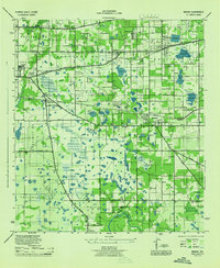
Mango, Seffner, and Brandon anchor this 1940s landscape, illustrating the early development of Hillsborough County east of the bay. The map reflects a rural economy transitioning through the mid-20th century, where established communities are linked by the Atlantic Coast Line and Seaboard Air Line railroads. The prevalence of small water bodies like Mango Lake, Lake Weeks, and Gornfo Lake indicates a naturally well-watered region, while the Alafia River and Buckhorn Creek define the southern drainage.
Find a feature on this map
54 named features on this map. Tap any name to fly to it.
Don’t see what you’re looking for? This feature index may not catch every label — zoom into the map to look around manually.
Map Details
Editions of this 1944 Mango Map
This is the sole edition of this map. No revisions or reprints were ever made.
Historical Maps of Tampa Through Time
1 maps found