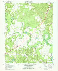
1968 Map of Manquin
USGS Topo · Published 1972About this map
The Pamunkey River winds through the heart of the Tidewater landscape, forming the boundary between King William and Hanover counties. In the late 1960s, this rural corridor was defined by small crossroads settlements and agricultural activity, with the Pamunkey River Bridge serving as a primary crossing point. Local history is anchored by numerous community landmarks, including Old Church, Farmers Shop Corner, and Enfield.
Find a feature on this map
41 named features on this map. Tap any name to fly to it.
Don’t see what you’re looking for? This feature index may not catch every label — zoom into the map to look around manually.
Map Details
Editions of this 1968 Manquin Map
2 editions found
Other maps of this area

1894 · Richmond
USGS Topo · 1:62,500

1895 · Richmond
USGS Topo · 1:62,500

1918 · Doswell
USGS Topo · 1:62,500

1918 · Aylett
USGS Topo · 1:62,500

1920 · King William
USGS Topo · 1:62,500

1933 · Aylett
USGS Topo · 1:62,500

1934 · Seven Pines
USGS Topo · 1:24,000

1938 · Seven Pines
USGS Topo · 1:31,680

1938 · Studley
USGS Topo · 1:31,680

1943 · Richmond
USGS Topo · 1:250,000