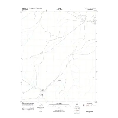
2011 Map of Many Farms SW
USGS Topo · Published 2011About this map
Many Farms and the smaller settlement of Maito define the human geography of this high-desert landscape within the Navajo Nation. The map illustrates a network of vital water sources in an arid climate, specifically the cluster of Alamo Spring, Sunrise Spring, Scott Spring, and Coyote Springs. These reliable watering points and drainage features like Hipbone Wash dictate the layout of traditional routes and modern roads, including Indian Rte 59 and Indian Rte 8083. A notable natural landmark, Window Rock, stands as a significant terrain feature in the central portion of the quadrangle. The sparse distribution of habitation around Many Farms reflects a communal reliance on both modern infrastructure and the geographic permanence of natural springs.
Find a feature on this map
13 named features on this map. Tap any name to fly to it.
Don’t see what you’re looking for? This feature index may not catch every label — zoom into the map to look around manually.
Map Details
Editions of this 2011 Many Farms SW Map
This is the sole edition of this map. No revisions or reprints were ever made.
Other maps of this area

1892 · Canyon De Chelly
USGS Topo · 1:250,000

1954 · Shiprock
USGS Topo · 1:250,000

1955 · Chinle 4 NE
USGS Topo · 1:24,000

1958 · Shiprock
USGS Topo · 1:250,000

1959 · Shiprock
USGS Topo · 1:250,000
1968 · Many Farms NE
USGS Topo · 1:24,000

1968 · Many Farms SW
USGS Topo · 1:24,000

1968 · Windy Valley
USGS Topo · 1:24,000
1968 · Many Farms
USGS Topo · 1:24,000
1968 · Rough Rock
USGS Topo · 1:24,000