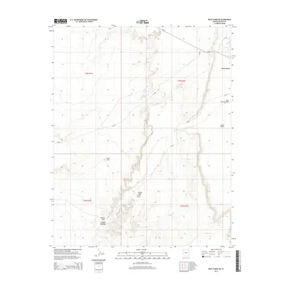
2014 Map of Many Farms SW
USGS Topo · Published 2014About this map
Chinle Valley dominates this landscape within the Navajo Nation, where the settlement of Many Farms sits at the edge of the plateau. The topography is defined by the significant rise of Carson Mesa to the west and the distinctive formation at Window Rock further south. Water sources, vital in this arid environment, are specifically identified through a network of springs and seasonal drainages, including Alamo Spring, Sunrise Spring, and Coyote Springs.
Find a feature on this map
21 named features on this map. Tap any name to fly to it.
Don’t see what you’re looking for? This feature index may not catch every label — zoom into the map to look around manually.
Map Details
Editions of this 2014 Many Farms SW Map
This is the sole edition of this map. No revisions or reprints were ever made.
Other maps of this area

1892 · Canyon De Chelly
USGS Topo · 1:250,000

1954 · Shiprock
USGS Topo · 1:250,000

1955 · Chinle 4 NE
USGS Topo · 1:24,000

1958 · Shiprock
USGS Topo · 1:250,000

1959 · Shiprock
USGS Topo · 1:250,000
1968 · Many Farms NE
USGS Topo · 1:24,000

1968 · Many Farms SW
USGS Topo · 1:24,000

1968 · Windy Valley
USGS Topo · 1:24,000
1968 · Many Farms
USGS Topo · 1:24,000
1968 · Rough Rock
USGS Topo · 1:24,000