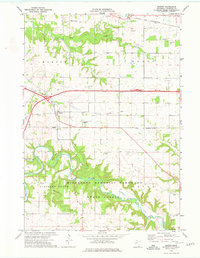
1974 Map of Marion
USGS Topo · Published 1976About this map
Marion serves as a central hub in this Olmsted County landscape, where the rural topography is defined by the winding paths of Bear Creek and the North Branch Root River. The 1970s era is marked by the presence of transportation infrastructure ranging from the private Sizer Airport to the heavy tracks of the Chicago and North Western railroad. Evidence of earlier logistical routes is visible in the Old Railroad Grade that cuts through the terrain near Predmore. This survey documents a transition in land use, where agricultural fields and small settlements like Cummingsville border the expansive Minnesota Memorial Hardwood State Forest. The map also preserves local genealogical landmarks, including Holy Redeemer Cem, Oak Grove Cem, and Orion Center Cem, providing a detailed look at the community's established history during a decade of regional growth.
Find a feature on this map
37 named features on this map. Tap any name to fly to it.
Don’t see what you’re looking for? This feature index may not catch every label — zoom into the map to look around manually.
Map Details
Editions of this 1974 Marion Map
This is the sole edition of this map. No revisions or reprints were ever made.
Other maps of this area

1934 · Plainview
USGS Topo · 1:62,500

1935 · Rochester
USGS Topo · 1:48,000

1938 · Plainview
USGS Topo · 1:62,500

1939 · Rochester
USGS Topo · 1:62,500

1953 · Saint Paul
USGS Topo · 1:250,000

1954 · Chatfield
USGS Topo · 1:62,500

1954 · Mason City
USGS Topo · 1:250,000

1955 · Stewartville
USGS Topo · 1:62,500

1957 · Mason City
USGS Topo · 1:250,000

1958 · Mason City
USGS Topo · 1:250,000