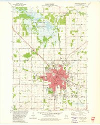
1979 Map of Marshfield
USGS Topo · Published 1980About this map
Marshfield serves as the regional anchor of the Wisconsin dairy belt in this 1970s record, situated at the intersection of the Soo Line and Chicago and North Western railroads. The city's growth is evident through its extensive school system, including Columbus High Sch and the University of Wis (Marshfield-Wood Co Campus). While the urban center is densely developed with landmarks like the Fairground and Wildwood Park, the northern landscape is dominated by the sprawling Mc Millan Marsh State Public Hunting Grounds, where the Little Eau Pleine River and MC Millan Marsh create a complex wetland environment.
Find a feature on this map
69 named features on this map. Tap any name to fly to it.
Don’t see what you’re looking for? This feature index may not catch every label — zoom into the map to look around manually.
Map Details
Editions of this 1979 Marshfield Map
This is the sole edition of this map. No revisions or reprints were ever made.
Other maps of this area

1902 · Marathon
USGS Topo · 1:125,000

1953 · Abbotsford
USGS Topo · 1:48,000

1953 · Stratford
USGS Topo · 1:48,000

1953 · Eau Claire
USGS Topo · 1:250,000

1954 · Granton
USGS Topo · 1:62,500

1954 · Marshfield
USGS Topo · 1:62,500

1958 · Eau Claire
USGS Topo · 1:250,000

1963 · Stratford
USGS Topo · 1:62,500

1963 · Abbotsford
USGS Topo · 1:62,500

1964 · Eau Claire
USGS Topo · 1:250,000