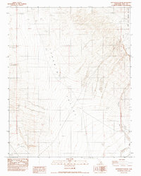
1982 Map of Maturango Peak NE
USGS Topo · Published 1983About this map
Panamint Valley dominates this 1982 provisional survey, showcasing a stark desert landscape where the basin floor meets the rising slopes of the Inyo County mountains. The northeastern corner of the map captures a portion of the Death Valley National Monument boundary, providing a detailed look at the interface between the national monument and the surrounding public lands. The topographical data reveals a transition from the broad, flat reaches of the Alkali Flat to the drainage patterns of Wildrose Wash. Local evidence of past resource exploration or cattle ranching appears via the label for a Dry Well, marking a site where water was sought but not sustained in this arid environment. The map captures the area as it was recorded during field checks in the late 1970s, reflecting a period when this high desert region remained largely undeveloped and defined by its natural drainage and geologic features.
Find a feature on this map
7 named features on this map. Tap any name to fly to it.
Don’t see what you’re looking for? This feature index may not catch every label — zoom into the map to look around manually.
Map Details
Editions of this 1982 Maturango Peak NE Map
This is the sole edition of this map. No revisions or reprints were ever made.
Other maps of this area

1908 · Ballarat
USGS Topo · 1:250,000

1913 · Ballarat
USGS Topo · 1:250,000

1948 · Death Valley
USGS Topo · 1:250,000

1951 · Panamint Butte
USGS Topo · 1:62,500

1951 · Maturango Peak
USGS Topo · 1:62,500

1952 · Telescope Peak
USGS Topo · 1:62,500

1952 · Emigrant Canyon
USGS Topo · 1:62,500

1954 · Death Valley
USGS Topo · 1:250,000

1956 · Death Valley
USGS Topo · 1:250,000

1957 · Death Valley
USGS Topo · 1:250,000