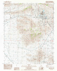
1983 Map of Mescal Range
USGS Topo · Published 1983About this map
Mountain Pass serves as a focal point for activity along the northern reach of this desert survey, where mining operations and local water sources defined the human footprint in the early 1980s. The landscape is dominated by the Mescal Range and the Clark Mountain Range, with the broad expanse of Shadow Valley to the west. A heavy emphasis on extraction is evident through numerous named sites such as the Birthday Mine, Mohawk Mine, and the Blue Buzzard Mine. These industrial nodes are supported by critical water points in an arid environment, including Mexican Well and the Hardrock Queen Spring. To the south, Striped Mountain rises above Rogers Camp, illustrating a rugged topography where narrow 4WD tracks and washes like Wheaton Wash provide the primary means of navigating between these isolated work sites and settlements.
Find a feature on this map
27 named features on this map. Tap any name to fly to it.
Don’t see what you’re looking for? This feature index may not catch every label — zoom into the map to look around manually.
Map Details
Editions of this 1983 Mescal Range Map
This is the sole edition of this map. No revisions or reprints were ever made.
Other maps of this area

1910 · Ivanpah
USGS Topo · 1:250,000

1912 · Ivanpah
USGS Topo · 1:250,000

1942 · Ivanpah
USGS Topo · 1:250,000

1947 · Kingman
USGS Topo · 1:250,000

1948 · Kingman
USGS Topo · 1:250,000

1954 · Kingman
USGS Topo · 1:250,000

1955 · Kingman
USGS Topo · 1:250,000

1955 · Mescal Range
USGS Topo · 1:62,500

1955 · Roach Lake
USGS Topo · 1:62,500

1956 · Ivanpah
USGS Topo · 1:62,500