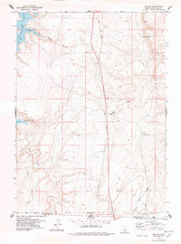
1978 Map of Meteor
USGS Topo · Published 1978About this map
Salmon Falls Creek Reservoir dominates the northwestern corner of this high-desert landscape, where the water is tucked behind the steep breaks of Browns Bench. This late 1970s survey captures a transition point on the Idaho-Nevada border, where the Union Pacific railroad corridor serves as the primary artery through the sagebrush plains. Small settlements like Meteor and Idavada represent the sparse human footprint in this rugged region of Twin Falls County, often centered on vital water sources and rail access.
Find a feature on this map
24 named features on this map. Tap any name to fly to it.
Don’t see what you’re looking for? This feature index may not catch every label — zoom into the map to look around manually.
Map Details
Editions of this 1978 Meteor Map
This is the sole edition of this map. No revisions or reprints were ever made.
Other maps of this area

1955 · Twin Falls
USGS Topo · 1:250,000

1955 · Wells
USGS Topo · 1:250,000

1957 · Contact
USGS Topo · 1:62,500

1957 · Delaplain
USGS Topo · 1:62,500

1958 · Wells
USGS Topo · 1:250,000

1958 · Twin Falls
USGS Topo · 1:250,000

1961 · Wells
USGS Topo · 1:250,000

1977 · Browns Bench South
USGS Topo · 1:24,000

1977 · Rogerson
USGS Topo · 1:24,000

1977 · Magic Hot Springs
USGS Topo · 1:24,000