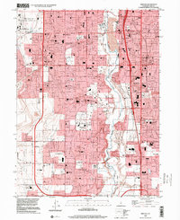
1999 Map of Midvale
USGS Topo · Published 2001About this map
The Jordan River corridor serves as the central spine of this Salt Lake Valley landscape, where rapid suburban expansion meets established public institutions. Large-scale facilities such as the Utah State Prison and the Utah National Guard Headquarters occupy significant tracts near the river, while the Salt Lake County Equestrian Park and Riverbend Golf Course reflect the area's recreational development. The map details a dense network of local schools, from Oquirrh Sch to Bingham High Sch, supporting the growing communities of Midvale, West Jordan, and South Jordan.
Find a feature on this map
61 named features on this map. Tap any name to fly to it.
Don’t see what you’re looking for? This feature index may not catch every label — zoom into the map to look around manually.
Map Details
Editions of this 1999 Midvale Map
This is the sole edition of this map. No revisions or reprints were ever made.
Other maps of this area

1885 · Salt Lake
USGS Topo · 1:250,000

1885 · Tooele Valley
USGS Topo · 1:250,000

1915 · Fairfield
USGS Topo · 1:62,500

1917 · Fairfield
USGS Topo · 1:62,500

1925 · Ft. Douglas
USGS Topo · 1:125,000

1928 · Ft. Douglas
USGS Topo · 1:125,000

1951 · Jordan Narrows
USGS Topo · 1:24,000

1951 · Lehi
USGS Topo · 1:24,000

1951 · Salt Lake City South
USGS Topo · 1:24,000

1951 · Midvale
USGS Topo · 1:24,000