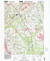
1999 Map of Milford Square
USGS Topo · Published 2001About this map
Spinnerstown and the surrounding townships of Milford, Upper Milford, and Lower Milford anchor this landscape at the close of the twentieth century. The geography is defined by a dense concentration of religious and educational landmarks, including St Johns Ch, Great Swamp Ch, and Swamp Ch, alongside small rural institutions like Union Sch and Milford Sch. This area, situated where Lehigh, Bucks, and Montgomery counties meet, shows a transition from historical village centers such as Trumbauersville and Geryville to modern infrastructure. The Pennsylvania Turnpike Northeast Extension bisects the terrain, crossing Licking Creek and Molasses Lane, while older routes like Old Bethlehem Road continue to serve local communities. Industrial and utility sites, including a Substation and Sewage Disposal Plant, appear alongside recreational spaces like Camp Rockwood and the northern reaches of Green Lane Reservoir County Park.
Find a feature on this map
88 named features on this map. Tap any name to fly to it.
Don’t see what you’re looking for? This feature index may not catch every label — zoom into the map to look around manually.
Map Details
Editions of this 1999 Milford Square Map
This is the sole edition of this map. No revisions or reprints were ever made.
Other maps of this area

1888 · Quakertown
USGS Topo · 1:62,500

1890 · Quakertown
USGS Topo · 1:62,500

1894 · Allentown
USGS Topo · 1:62,500

1894 · Quakertown
USGS Topo · 1:62,500

1902 · Boyertown
USGS Topo · 1:62,500

1902 · Slatington
USGS Topo · 1:62,500

1937 · Allentown West
USGS Topo · 1:48,000

1939 · Allentown
USGS Topo · 1:62,500

1942 · Norristown
USGS Topo · 1:125,000

1942 · Allentown West
USGS Topo · 1:62,500