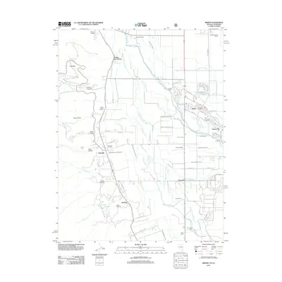
2012 Map of Minden
USGS Topo · Published 2012About this map
Carson Valley and the Carson Range are depicted here during a period of sustained agricultural and suburban growth in Douglas County. The dual hubs of Minden and Gardnerville anchor the eastern landscape, defined by a complex network of historic irrigation and drainage features like Martin Slough and the East Fork Carson River. For genealogists and local historians, the sheet preserves the locations of three distinct burial grounds: Captain George Cemetery, Mottsville Cemetery, and the Millers Gardnerville Cemetery.
Find a feature on this map
74 named features on this map. Tap any name to fly to it.
Don’t see what you’re looking for? This feature index may not catch every label — zoom into the map to look around manually.
Map Details
Editions of this 2012 Minden Map
This is the sole edition of this map. No revisions or reprints were ever made.
Other maps of this area

1889 · Markleeville
USGS Topo · 1:125,000

1891 · Carson
USGS Topo · 1:125,000

1891 · Markleeville
USGS Topo · 1:125,000

1893 · Carson
USGS Topo · 1:125,000

1893 · Markleeville
USGS Topo · 1:125,000

1948 · Walker Lake
USGS Topo · 1:250,000
1955 · Freel Peak
USGS Topo · 1:24,000

1955 · Bijou
USGS Topo · 1:24,000

1955 · Glenbrook
USGS Topo · 1:24,000

1956 · Freel Peak
USGS Topo · 1:62,500