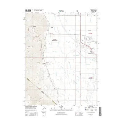
2014 Map of Minden
USGS Topo · Published 2014About this map
The Carson Valley serves as a dramatic transition between the high peaks of the Carson Range and the agricultural lowlands of the Carson River basin. This 2014 survey captures the distinct settlement patterns of Douglas County, from the established centers of Minden and Gardnerville to the historic footprints at Genoa and Mottsville. The landscape is defined by an intricate network of irrigation and drainage, including the Saint Louis Straight Ditch and numerous sloughs like Home Slough and Brockliss Slough, which support the valley's ranching heritage. Along the western edge, the terrain rises sharply into the Toiyabe National Forest, where deep cuts like Haines Canyon and Taylor Canyon overlook the valley floor. Genealogists can identify several burial sites, including the Mottsville Cemetery and Captain George Cemetery, while landmarks like Walleys Hot Springs highlight the area's long-standing connection to its natural thermal features.
Find a feature on this map
67 named features on this map. Tap any name to fly to it.
Don’t see what you’re looking for? This feature index may not catch every label — zoom into the map to look around manually.
Map Details
Editions of this 2014 Minden Map
This is the sole edition of this map. No revisions or reprints were ever made.
Other maps of this area

1889 · Markleeville
USGS Topo · 1:125,000

1891 · Carson
USGS Topo · 1:125,000

1891 · Markleeville
USGS Topo · 1:125,000

1893 · Carson
USGS Topo · 1:125,000

1893 · Markleeville
USGS Topo · 1:125,000

1948 · Walker Lake
USGS Topo · 1:250,000
1955 · Freel Peak
USGS Topo · 1:24,000

1955 · Bijou
USGS Topo · 1:24,000

1955 · Glenbrook
USGS Topo · 1:24,000

1956 · Freel Peak
USGS Topo · 1:62,500