1974 Map of Minden
USGS Topo · Published 1974About this map
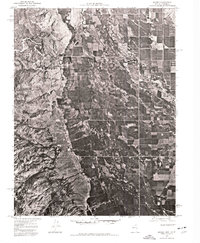
Carson Valley serves as the central focal point of this 1974 orthophotoquad, showcasing the intensive agricultural layout and riparian network of western Nevada during the mid-1970s. The settlement of Minden is visible on the eastern edge of the valley floor, where the town's street grid and development contrast sharply with the expansive rectilinear fields that surround it. The hydrology of the region is clearly defined by the Carson River and the East Fork Carson River, which meander through the valley, supporting the irrigation systems essential to this high-desert farming community. This aerial perspective, captured on July 4, 1974, provides a precise record of land use and water distribution before the subsequent decades of residential growth altered the traditional ranching and farming landscape of Douglas County.
Find a feature on this map
4 named features on this map. Tap any name to fly to it.
Don’t see what you’re looking for? This feature index may not catch every label — zoom into the map to look around manually.
Map Details
Editions of this 1974 Minden Map
This is the sole edition of this map. No revisions or reprints were ever made.
Other maps of this area

1889 · Markleeville
USGS Topo · 1:125,000

1891 · Carson
USGS Topo · 1:125,000

1891 · Markleeville
USGS Topo · 1:125,000

1893 · Carson
USGS Topo · 1:125,000

1893 · Markleeville
USGS Topo · 1:125,000

1948 · Walker Lake
USGS Topo · 1:250,000
1955 · Freel Peak
USGS Topo · 1:24,000
1955 · Bijou
USGS Topo · 1:24,000
1955 · Glenbrook
USGS Topo · 1:24,000

1956 · Freel Peak
USGS Topo · 1:62,500