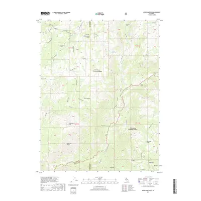
2018 Map of Mokelumne Peak
USGS Topo · Published 2018About this map
Hungalelti Ridge and the Mokelumne Tetons dominate this high-altitude landscape where the borders of Amador, Alpine, and Calaveras counties converge. This 2018 survey reveals a terrain defined by historical passage and seasonal grazing, marked by the iconic Carson Emigrant N. R. T. which follows the ridges north of Bear River. The map details a complex network of meadows and springs, such as Munson Meadow and Horse Thief Spring, which have long supported trans-Sierran travel and livestock. To the south, the S Fork Mokelumne River and N Fork Mokelumne River carve through deep canyons like Fourth of July Canyon, framing the ascent to Mokelumne Peak. These features reflect the dual heritage of the region as both a protected wilderness within the Eldorado National Forest and a site of persistent mountain industry near Snow Valley.
Find a feature on this map
55 named features on this map. Tap any name to fly to it.
Don’t see what you’re looking for? This feature index may not catch every label — zoom into the map to look around manually.
Map Details
Editions of this 2018 Mokelumne Peak Map
This is the sole edition of this map. No revisions or reprints were ever made.
Other maps of this area

1889 · Pyramid Peak
USGS Topo · 1:125,000

1889 · Markleeville
USGS Topo · 1:125,000

1891 · Markleeville
USGS Topo · 1:125,000

1891 · Big Trees
USGS Topo · 1:125,000

1891 · Pyramid Peak
USGS Topo · 1:125,000

1893 · Markleeville
USGS Topo · 1:125,000

1894 · Big Trees
USGS Topo · 1:125,000

1895 · Pyramid Peak
USGS Topo · 1:125,000

1896 · Dardanelles
USGS Topo · 1:125,000

1896 · Pyramid Peak
USGS Topo · 1:125,000