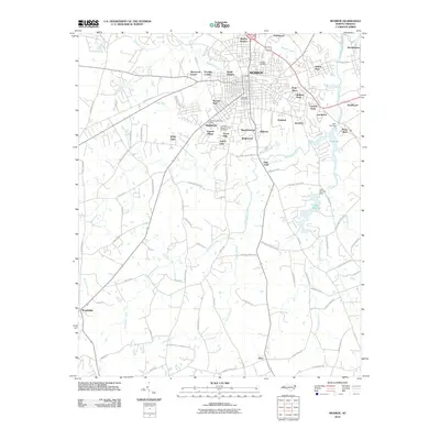
2010 Map of Monroe
USGS Topo · Published 2010About this map
Monroe serves as the hub of this Union County landscape, where urban neighborhoods transition into a network of creeks and small residential developments. The area's growth is reflected in the numerous named subdivisions such as Sherwood Forest, Franklin Colony, and Kingswood, while older history is preserved at Hillcrest Cemetery and Lakeland Memorial Park Cemetery. Natural drainage is defined by the winding course of Richardson Creek and its many tributaries, including Adams Branch and Beaverdam Creek. To the east, the impoundments of Lake Monroe and Lake Lee provide significant water features. The southern portion of the quadrangle remains less densely settled, anchored by the community of Alton and the junction at Roughledge, where the road network follows the undulating terrain of the Piedmont plateau.
Find a feature on this map
89 named features on this map. Tap any name to fly to it.
Don’t see what you’re looking for? This feature index may not catch every label — zoom into the map to look around manually.
Map Details
Editions of this 2010 Monroe Map
This is the sole edition of this map. No revisions or reprints were ever made.
Other maps of this area

1941 · Charlotte
USGS Topo · 1:125,000

1941 · Spartanburg
USGS Topo · 1:250,000

1942 · Charlotte
USGS Topo · 1:125,000

1953 · Spartanburg
USGS Topo · 1:250,000

1953 · Charlotte
USGS Topo · 1:250,000

1954 · Charlotte
USGS Topo · 1:250,000

1960 · Charlotte
USGS Topo · 1:250,000

1960 · Spartanburg
USGS Topo · 1:250,000

1962 · Charlotte
USGS Topo · 1:250,000

1963 · Spartanburg
USGS Topo · 1:250,000