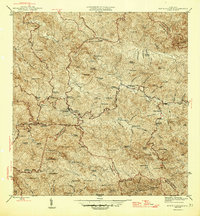
1946 Map of Monte Guilarte
USGS Topo · Published 1946About this map
The Cordillera Central defines the heart of this mid-century survey, revealing a landscape defined by the agrarian economy of the Puerto Rican interior. Numerous family-owned estates, such as Hacienda San Alberto, Hacienda El Fenix, and Hacienda La Esperanza, are scattered across the high ridges and deep valleys, illustrating the density of mountain coffee and fruit production before later industrial shifts. The intersection of local governance and community life is visible through municipal boundaries meeting near Monte Guilarte and the placement of rural institutions like the Iglesia de la Virgen del Carmen and Escuela Segunda Unidad de Yahueca. Waterways such as the Rio Grande and Rio Prieto serve as the primary geographical markers for these settlements, with traditional colonial-era place names persisting alongside new infrastructure like 8 and 64.
Find a feature on this map
104 named features on this map. Tap any name to fly to it.
Don’t see what you’re looking for? This feature index may not catch every label — zoom into the map to look around manually.
Map Details
Editions of this 1946 Monte Guilarte Map
3 editions found
Other maps of this area

1937 · Sabana Grande
USGS Topo · 1:25,000

1938 · San Sebastian
USGS Topo · 1:20,000

1941 · San Sebastian
USGS Topo · 1:30,000

1941 · Sabana Grande
USGS Topo · 1:30,000

1946 · Maricao
USGS Topo · 1:30,000

1946 · Utuado
USGS Topo · 1:30,000

1946 · Bayaney
USGS Topo · 1:30,000

1946 · Yauco
USGS Topo · 1:30,000

1946 · Monte Guilarte
USGS Topo · 1:30,000

1946 · Penuelas
USGS Topo · 1:30,000
Featured Places
- Sector Los Pagán, Adjuntas
- Sector Palo Seco, Adjuntas
- Sector Jiménez Santiago, Adjuntas
- Sector Titulo Quinto, Adjuntas
- Sector Lombrices, Adjuntas