1972 Map of Moodys
USGS Topo · Published 1974About this map
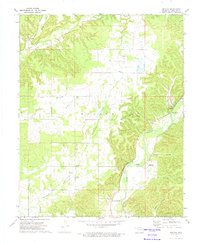
The Illinois River winds through the eastern portion of this quadrant, defining a landscape marked by steep bluffs and deep hollows in Cherokee County. Local life in the early 1970s centered on small settlements like Moodys and Lowrey, where the Lowrey Sch and numerous country churches provided community anchors. The map reveals a dense network of small religious sites, including Johnson Prairie Ch, Grace Chapel, and Olive Ch, alongside family and community burial grounds such as Agent Cem. Along the river, landmarks like Hanging Rock and Eagles Bluff overlook the water, while the Combs Bridge provides a vital crossing point. Further west, the drainage of Fourteenmile Creek and Spring Creek creates a more rolling terrain where the hamlet of Teresita is situated near the Teresita Cem.
Find a feature on this map
31 named features on this map. Tap any name to fly to it.
Don’t see what you’re looking for? This feature index may not catch every label — zoom into the map to look around manually.
Map Details
Editions of this 1972 Moodys Map
This is the sole edition of this map. No revisions or reprints were ever made.
Other maps of this area

1896 · Pryor
USGS Topo · 1:125,000

1898 · Tahlequah
USGS Topo · 1:125,000

1899 · Siloam Springs
USGS Topo · 1:125,000

1901 · Muscogee
USGS Topo · 1:125,000

1901 · Pryor
USGS Topo · 1:125,000

1901 · Tahlequah
USGS Topo · 1:125,000

1903 · Siloam Springs
USGS Topo · 1:125,000

1904 · Siloam Springs
USGS Topo · 1:125,000

1905 · Muscogee
USGS Topo · 1:125,000

1905 · Tahlequah
USGS Topo · 1:125,000