1971 Map of Morton
USGS Topo · Published 1973About this map
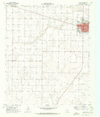
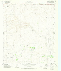
Morton serves as the focal point of this 1971 topographic study, its street grid organized around a central corridor including Main St and Washington Ave. As the seat of Cochran County, the town features established community infrastructure such as the High Sch, a Hospital, and a designated Park. Beyond the residential core, the landscape transitions into a vast expanse of agricultural survey blocks defined by a network of farm roads and the diagonal path of the Star Route.
Find a feature on this map
22 named features on this map. Tap any name to fly to it.
Don’t see what you’re looking for? This feature index may not catch every label — zoom into the map to look around manually.
Map Details
Editions of this 1971 Morton Map
This is the sole edition of this map. No revisions or reprints were ever made.
Other maps of this area

1954 · Brownfield
USGS Topo · 1:250,000

1958 · Brownfield
USGS Topo · 1:250,000

1962 · Brownfield
USGS Topo · 1:250,000
1969 · Maple
USGS Topo · 1:24,000
1969 · Enochs
USGS Topo · 1:24,000
1969 · Lehman
USGS Topo · 1:24,000
1970 · Morton SW
USGS Topo · 1:24,000
1970 · Whiteface SW
USGS Topo · 1:24,000
1970 · Morton NW
USGS Topo · 1:24,000
1971 · Whiteface NW
USGS Topo · 1:24,000