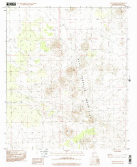
1996 Map of Mount Aden SW
USGS Topo · Published 2001About this map
The West Potrillo Mountains dominate this high-desert landscape in Doña Ana County, revealing a complex volcanic topography of cinder cones and craters. Based on field work from the mid-1970s and photo-inspected in the mid-1990s, the map documents a sparse but essential network of water sources necessary for ranching and survival in this arid environment. Named catchment features such as Salty Tank, Cow Tank, and the ephemeral Dry Lake are scattered across the terrain, indicating the historical reliance on seasonal runoff. A lone Corral and a prominent Sinkhole provide further evidence of the land's geological character and its use for livestock management. This topographic study captures the isolation of the southern New Mexico desert before modern digital mapping, preserving the specific locations of landmarks vital to local navigation and land use history.
Find a feature on this map
6 named features on this map. Tap any name to fly to it.
Don’t see what you’re looking for? This feature index may not catch every label — zoom into the map to look around manually.
Map Details
Editions of this 1996 Mount Aden SW Map
This is the sole edition of this map. No revisions or reprints were ever made.
Other maps of this area

1917 · Camel Mountain
USGS Topo · 1:62,500

1917 · Mt. Riley
USGS Topo · 1:62,500

1918 · Mt. Riley
USGS Topo · 1:62,500

1929 · Mt. Riley
USGS Topo · 1:62,500

1941 · Aden
USGS Topo · 1:62,500

1943 · Aden
USGS Topo · 1:62,500

1951 · Mt. Riley
USGS Topo · 1:62,500

1953 · El Paso
USGS Topo · 1:250,000

1955 · Las Cruces
USGS Topo · 1:250,000

1958 · Las Cruces
USGS Topo · 1:250,000