
1915 Map of Mt. Baker Dist
USGS Topo · Published 1947About this map
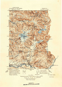
Mt Baker and its massive ice fields, including the Coleman Glacier and Mazama Glacier, dominate this early twentieth-century survey of the North Cascades. The map documents an era of burgeoning industrial and recreational interest in the Mt Baker National Forest, evidenced by the Excelsior Power Plant and early homesteads like Morovits Ranch. To the south, the Great Northern Railway corridor follows the Skagit River, linking riverfront settlements like Concrete, Birdsview, and Marblemount. High-altitude mining history is preserved at the Lone Jack Mine near the United States Canada Boundary Line. This topography reveals the transition from valley-floor ranching at Thompsons Ranch to the alpine wilderness of the Skagit Range, providing a detailed view of the region before modern infrastructure altered its early character.
Find a feature on this map
86 named features on this map. Tap any name to fly to it.
Don’t see what you’re looking for? This feature index may not catch every label — zoom into the map to look around manually.
Map Details
Editions of this 1915 Mt. Baker Dist Map
3 editions found

Historical Maps of Glacier Through Time
116 maps found

1909 Mt. Baker
Whatcom County, WA
1915 Mt. Baker Dist
Whatcom County, WA

1919 Van Zandt
Whatcom County, WA

1951 Van Zandt
Whatcom County, WA

1952 Bertrand Creek
Whatcom County, WA

1952 Birch Point
Whatcom County, WA

1952 Lake Whatcom
Whatcom County, WA

1952 Lawrence
Whatcom County, WA

1952 Lummi Bay
Whatcom County, WA

1952 Mt. Baker
Whatcom County, WA

1953 Mt Challenger
Whatcom County, WA

1953 Mt Shuksan
Whatcom County, WA

1954 Bellingham North
Whatcom County, WA

1954 Bellingham South
Whatcom County, WA

1957 Victoria
Whatcom County, WA

1963 Azurite Peak
Whatcom County, WA

1963 Crater Mountain
Whatcom County, WA

1963 Diablo Dam
Whatcom County, WA

1963 Ross Dam
Whatcom County, WA

1969 Hozomeen Mtn
Whatcom County, WA

1969 Jack Mtn
Whatcom County, WA

1969 Mt Prophet
Whatcom County, WA

1969 Mt Spickard
Whatcom County, WA

1969 Pumpkin Mtn.
Whatcom County, WA

1969 Shull Mtn.
Whatcom County, WA

1969 Skagit Peak
Whatcom County, WA

1972 Canyon Lake
Whatcom County, WA

1977 Eliza Island
Whatcom County, WA

1978 Lummi Island
Whatcom County, WA

1979 Mt. Baker
Whatcom County, WA

1980 Cavanaugh Creek
Whatcom County, WA

1989 Bacon Peak
Whatcom County, WA

1989 Baker Pass
Whatcom County, WA

1989 Bearpaw Mountain
Whatcom County, WA

1989 Copper Mountain
Whatcom County, WA

1989 Damnation Peak
Whatcom County, WA

1989 Groat Mountain
Whatcom County, WA

1989 Mount Baker
Whatcom County, WA

1989 Mount Blum
Whatcom County, WA

1989 Mount Sefrit
Whatcom County, WA

1989 Mount Shuksan
Whatcom County, WA

1989 Mount Triumph
Whatcom County, WA

1989 Mt Challenger
Whatcom County, WA

1989 Mt Larrabee
Whatcom County, WA

1989 Mt Redoubt
Whatcom County, WA

1989 Shuksan Arm
Whatcom County, WA

1989 Twin Sisters Mtn.
Whatcom County, WA

1989 Welker Peak
Whatcom County, WA

1998 Bellingham South
Whatcom County, WA

1998 Eliza Island
Whatcom County, WA

1998 Lummi Island
Whatcom County, WA

1999 Bacon Peak
Whatcom County, WA

1999 Damnation Peak
Whatcom County, WA

1999 Mount Triumph
Whatcom County, WA

2002 Azurite Peak
Whatcom County, WA

2002 Castle Peak
Whatcom County, WA

2002 Hozomeen Mountain
Whatcom County, WA

2002 Jack Mountain
Whatcom County, WA

2002 Pumpkin Mountain
Whatcom County, WA

2002 Shull Mountain
Whatcom County, WA

2002 Skagit Peak
Whatcom County, WA

2023 Azurite Peak
Whatcom County, WA

2023 Bacon Peak
Whatcom County, WA

2023 Baker Pass
Whatcom County, WA

2023 Bearpaw Mountain
Whatcom County, WA

2023 Bellingham North
Whatcom County, WA

2023 Bellingham South
Whatcom County, WA

2023 Bertrand Creek OE N
Whatcom County, WA

2023 Bertrand Creek
Whatcom County, WA

2023 Birch Point OE N
Whatcom County, WA

2023 Birch Point
Whatcom County, WA

2023 Blaine OE N
Whatcom County, WA

2023 Canyon Lake
Whatcom County, WA

2023 Castle Peak
Whatcom County, WA

2023 Cavanaugh Creek
Whatcom County, WA

2023 Copper Mountain
Whatcom County, WA

2023 Crater Mountain
Whatcom County, WA

2023 Damnation Peak
Whatcom County, WA

2023 Diablo Dam
Whatcom County, WA

2023 Eliza Island
Whatcom County, WA

2023 Glacier OE N
Whatcom County, WA

2023 Groat Mountain
Whatcom County, WA

2023 Hozomeen Mountain OE N
Whatcom County, WA

2023 Hozomeen Mountain
Whatcom County, WA

2023 Jack Mountain
Whatcom County, WA

2023 Kendall OE N
Whatcom County, WA

2023 Lake Whatcom
Whatcom County, WA

2023 Lawrence
Whatcom County, WA

2023 Lummi Bay OE W
Whatcom County, WA

2023 Lummi Bay
Whatcom County, WA

2023 Lummi Island
Whatcom County, WA

2023 Lynden OE N
Whatcom County, WA

2023 Maple Falls OE N
Whatcom County, WA

2023 Mount Baker
Whatcom County, WA

2023 Mount Blum
Whatcom County, WA

2023 Mount Challenger
Whatcom County, WA

2023 Mount Larrabee
Whatcom County, WA

2023 Mount Prophet
Whatcom County, WA

2023 Mount Redoubt OE N
Whatcom County, WA

2023 Mount Redoubt
Whatcom County, WA

2023 Mount Sefrit
Whatcom County, WA

2023 Mount Shuksan
Whatcom County, WA

2023 Mount Spickard OE N
Whatcom County, WA

2023 Mount Spickard
Whatcom County, WA

2023 Mount Triumph
Whatcom County, WA

2023 Point Roberts OE N
Whatcom County, WA

2023 Pumpkin Mountain
Whatcom County, WA

2023 Ross Dam
Whatcom County, WA

2023 Shuksan Arm
Whatcom County, WA

2023 Shull Mountain
Whatcom County, WA

2023 Skagit Peak OE N
Whatcom County, WA

2023 Skagit Peak
Whatcom County, WA

2023 Strait of Georgia (All Water)
Whatcom County, WA

2023 Sumas OE N
Whatcom County, WA

2023 Twin Sisters Mountain
Whatcom County, WA

2023 Welker Peak
Whatcom County, WA