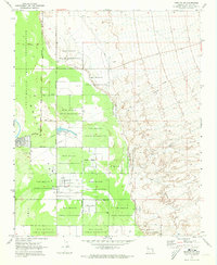
1970 Map of Needles NE
USGS Topo · Published 1973About this map
The Fort Mojave Indian Reservation dominates this landscape along the Arizona-California border, revealing a structured grid of residential streets and community infrastructure developed by 1970. This transition from open desert to organized settlement is evident in the layout of roads like Aguila Drive, Cottonwood Lane, and Laguna Road. Public and social life is anchored by the Rodeo Grounds and a nearby Radio Tower, while the Desert Lawn Cem serves as a significant genealogical marker for the region.
Find a feature on this map
23 named features on this map. Tap any name to fly to it.
Don’t see what you’re looking for? This feature index may not catch every label — zoom into the map to look around manually.
Map Details
Editions of this 1970 Needles NE Map
This is the sole edition of this map. No revisions or reprints were ever made.
Other maps of this area

1886 · Camp Mohave
USGS Topo · 1:250,000

1892 · Camp Mohave
USGS Topo · 1:250,000

1903 · Needles
USGS Topo · 1:125,000

1904 · Needles Special
USGS Topo · 1:125,000

1926 · Mohave City
USGS Topo · 1:96,000

1942 · Camp Mohave
USGS Topo · 1:250,000

1947 · Kingman
USGS Topo · 1:250,000

1948 · Kingman
USGS Topo · 1:250,000

1950 · Davis Dam
USGS Topo · 1:62,500

1950 · Needles
USGS Topo · 1:62,500