1992 Map of New Holland
USGS Topo · Published 1994About this map
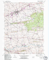
New Holland stands as a central hub in this corner of Lancaster County, surrounded by a dense network of smaller agricultural settlements and family-named landmarks. The landscape is defined by the prominent ridge of Welsh Mountain to the east and the fertile lowlands drained by Pequea Creek and Muddy Run. This document meticulously tracks the cultural footprint of the area, from the manufacturing and rail operations of Conrail in the larger towns to the numerous country schools like Maple Grove Sch and Hickory Grove Sch that dot the crossroads. A complex irrigation and milling history is evident in the various branches of Millrace near Buyerstown and New Milltown. The map also captures the distinct layout of local communities, including the village of Intercourse and the religious landmarks that anchor the rural population, such as Zeltenreich Ch and Lady of Lourdes.
Find a feature on this map
74 named features on this map. Tap any name to fly to it.
Don’t see what you’re looking for? This feature index may not catch every label — zoom into the map to look around manually.
Map Details
Editions of this 1992 New Holland Map
This is the sole edition of this map. No revisions or reprints were ever made.
Other maps of this area

1904 · Coatesville
USGS Topo · 1:62,500

1905 · Honey Brook
USGS Topo · 1:62,500

1906 · Coatesville
USGS Topo · 1:62,500

1906 · New Holland
USGS Topo · 1:62,500

1907 · Honeybrook
USGS Topo · 1:62,500

1908 · New Holland
USGS Topo · 1:62,500

1912 · Quarryville
USGS Topo · 1:62,500

1918 · Coatesville
USGS Topo · 1:62,500

1941 · Honeybrook
USGS Topo · 1:62,500

1941 · New Holland
USGS Topo · 1:62,500
Featured Places
- East Earl Township, PA
- New Holland, PA
- Paradise Township, PA
- Blue Ball, East Earl Township
- Leacock Township, PA