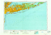
1954 Map of New York
USGS Topo · Published 1971About this map
Long Island dominates this mid-century landscape, appearing during a period of massive suburban expansion and infrastructure development. The map details the dense urban cores of New York City, Brooklyn, and Manhattan as they connect to emerging residential centers like Levittown and Hicksville via a growing network of parkways. The reliance on the Long Island Rail Road is evident, tracing the backbone of transportation from the city to the eastern reaches of Montauk and Orient Point. While the western end is heavily industrialized and populated, the eastern landscape maintains a series of protected maritime environments, including the Fire Island National Seashore and Wildwood State Park. This transition from the intense grid of the five boroughs to the rural character of Great Peconic Bay and Southampton illustrates the regional shift from an urban metropolis to a coastal retreat before the peak of late-century sprawl.
Find a feature on this map
157 named features on this map. Tap any name to fly to it.
Don’t see what you’re looking for? This feature index may not catch every label — zoom into the map to look around manually.
Map Details
Editions of this 1954 New York Map
2 editions found

Other maps of this area

1888 · Barnegat
USGS Topo · 1:62,500

1888 · Asbury Park
USGS Topo · 1:62,500

1888 · Paterson
USGS Topo · 1:62,500

1888 · Sandy Hook
USGS Topo · 1:62,500

1889 · Brooklyn
USGS Topo · 1:62,500

1891 · Ramapo
USGS Topo · 1:62,500

1891 · Brooklyn
USGS Topo · 1:62,500

1891 · Harlem
USGS Topo · 1:62,500

1891 · Bridgeport
USGS Topo · 1:62,500

1892 · Stamford
USGS Topo · 1:62,500