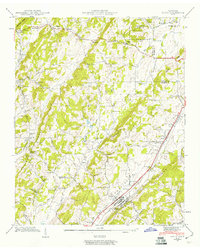
1941 Map of Niota
USGS Topo · Published 1960About this map
Niota serves as a primary rail-side hub in East Tennessee just before the mid-century, anchored by the Southern railroad and the parallel Southern Highway. The surrounding McMinn County countryside is dotted with small rural centers and agrarian industry, including Barton Mill on Little Mouse Creek and Acme Mill along the North Fork East Mouse Creek. These water-powered sites, along with crossroad settlements like Union Grove and Prigmore, reveal a landscape transitioning from traditional milling to modern transit. Local social life is mapped through numerous country congregations and schoolhouses such as Beulah Chapel, Pleasant Grove Ch, and Oak Grove Sch. The presence of the Niota Golf Course near the town center indicates early 20th-century recreational development alongside established family-named landmarks like Marshall Hill and Shearman Cem.
Find a feature on this map
95 named features on this map. Tap any name to fly to it.
Don’t see what you’re looking for? This feature index may not catch every label — zoom into the map to look around manually.
Map Details
Editions of this 1941 Niota Map
2 editions found
Other maps of this area

1886 · Cleveland
USGS Topo · 1:125,000

1887 · Kingston
USGS Topo · 1:125,000

1891 · Kingston
USGS Topo · 1:125,000

1892 · Cleveland
USGS Topo · 1:125,000

1893 · Murphy
USGS Topo · 1:125,000

1893 · Kingston
USGS Topo · 1:125,000

1895 · Cleveland
USGS Topo · 1:125,000

1895 · Loudon
USGS Topo · 1:125,000

1901 · Cleveland
USGS Topo · 1:125,000

1914 · Murphy
USGS Topo · 1:125,000