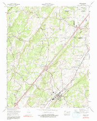
1974 Map of Niota
USGS Topo · Published 1991About this map
The town of Niota centers this 1974 survey, situated along the Southern Railway in the productive corridor of the Sweetwater Valley. The landscape is defined by its agrarian and industrial foundations, featuring a dense network of country churches like Beulah Chapel and Rockview Ch, alongside local commerce at Murray Store and Riddles Store. Milling operations, including Acme Mill and Barton Mill, reflect the historical processing of timber or grain near the area's numerous water sources like Big Sewee Creek and Mouse Creek.
Find a feature on this map
72 named features on this map. Tap any name to fly to it.
Don’t see what you’re looking for? This feature index may not catch every label — zoom into the map to look around manually.
Map Details
Editions of this 1974 Niota Map
3 editions found
Other maps of this area

1886 · Cleveland
USGS Topo · 1:125,000

1887 · Kingston
USGS Topo · 1:125,000

1891 · Kingston
USGS Topo · 1:125,000

1892 · Cleveland
USGS Topo · 1:125,000

1893 · Murphy
USGS Topo · 1:125,000

1893 · Kingston
USGS Topo · 1:125,000

1895 · Cleveland
USGS Topo · 1:125,000

1895 · Loudon
USGS Topo · 1:125,000

1901 · Cleveland
USGS Topo · 1:125,000

1914 · Murphy
USGS Topo · 1:125,000