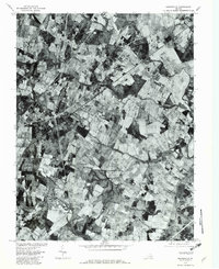
1977 Map of Nokesville
USGS Topo · Published 1982About this map
Nokesville and the surrounding Prince William County countryside are captured in this 1977 orthophotograph, showing a landscape defined by an intricate patchwork of woodlots and active agricultural fields. This unique perspective, produced by the Geological Survey and the Soil Conservation Service, emphasizes the rural character of the region before the significant suburban expansion of later decades. The drainage patterns of the Piedmont are clearly visible as Broad Run, Kettle Run, and Cedar Run wind through the terrain, their courses often marked by dense riparian vegetation that contrasts with the cleared farmland. Historically significant nodes like Brentsville and Bristow appear as small clusters of development along the road network. The map provides a sharp look at the spatial relationship between crossroads settlements such as Aden and Kings Crossroads, offering a clear record of land use and property boundaries in northern Virginia during the late 1970s.
Find a feature on this map
8 named features on this map. Tap any name to fly to it.
Don’t see what you’re looking for? This feature index may not catch every label — zoom into the map to look around manually.
Map Details
Editions of this 1977 Nokesville Map
This is the sole edition of this map. No revisions or reprints were ever made.
Other maps of this area

1890 · Mt. Vernon
USGS Topo · 1:125,000

1891 · Mt. Vernon
USGS Topo · 1:125,000

1894 · Warrenton
USGS Topo · 1:125,000

1894 · Mt. Vernon
USGS Topo · 1:125,000

1897 · Mt. Vernon
USGS Topo · 1:125,000

1915 · Fairfax
USGS Topo · 1:62,500

1927 · Quantico
USGS Topo · 1:62,500

1933 · Middleburg
USGS Topo · 1:62,500

1940 · Quantico
USGS Topo · 1:62,500

1943 · Quantico
USGS Topo · 1:62,500