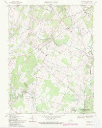
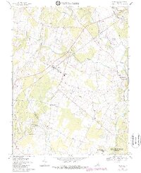
1966 Map of Nokesville
USGS Topo · Published 1994About this map
Nokesville and the surrounding Prince William County countryside appear as a landscape of small crossroads and rural institutions in the mid-1960s. The Southern railroad corridor anchors the northern half of the map, passing through Bristow and Nokesville as it heads toward the western edge of Manassas. The presence of several cemeteries, such as Valley View Cem and Colvin Cem, alongside landmarks like Brentsville High Sch and Asbury Ch, points to established family roots and community centers.
Find a feature on this map
35 named features on this map. Tap any name to fly to it.
Don’t see what you’re looking for? This feature index may not catch every label — zoom into the map to look around manually.
Map Details
Editions of this 1966 Nokesville Map
5 editions found
Other maps of this area

1890 · Mt. Vernon
USGS Topo · 1:125,000

1891 · Mt. Vernon
USGS Topo · 1:125,000

1894 · Warrenton
USGS Topo · 1:125,000

1894 · Mt. Vernon
USGS Topo · 1:125,000

1897 · Mt. Vernon
USGS Topo · 1:125,000

1915 · Fairfax
USGS Topo · 1:62,500

1927 · Quantico
USGS Topo · 1:62,500

1933 · Middleburg
USGS Topo · 1:62,500

1940 · Quantico
USGS Topo · 1:62,500

1943 · Quantico
USGS Topo · 1:62,500