
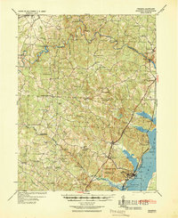
1940 Map of Quantico
USGS Topo · Published 1940About this map
The U S Marine Corps Reservation dominates the southern landscape of this 1940 tactical map, centering on the military presence at Quantico and the adjacent Brown Field. Along the Potomac River, the terrain transitions from the marshy shoreline near Chopawamsic Island to the higher ground of Cherry Hill. Inland, the map reveals a rural network of family-run commerce and small-town infrastructure, featuring locations like Minnieville Store, the District Workhouse, and Sinclairs Mill. The logistical importance of the region is evident in the Richmond Fredericksburg and Potomac RR corridor and the numerous river crossings, including Blands Ford Bridge and Woodyards Ford. From the Old Chopawamsic Church to the Bacon Race School, the map documents a community defined by its crossroads and water-powered industries before mid-century expansion.
Find a feature on this map
73 named features on this map. Tap any name to fly to it.
Don’t see what you’re looking for? This feature index may not catch every label — zoom into the map to look around manually.
Map Details
Editions of this 1940 Quantico Map
2 editions found
Other maps of this area

1887 · Spottsylvania
USGS Topo · 1:125,000

1889 · Fredericksburg
USGS Topo · 1:125,000

1890 · Mt. Vernon
USGS Topo · 1:125,000

1891 · Mt. Vernon
USGS Topo · 1:125,000

1892 · Fredericksburg
USGS Topo · 1:125,000

1892 · Spottsylvania
USGS Topo · 1:125,000

1894 · Warrenton
USGS Topo · 1:125,000

1894 · Fredericksburg
USGS Topo · 1:125,000

1894 · Mt. Vernon
USGS Topo · 1:125,000

1897 · Mt. Vernon
USGS Topo · 1:125,000