
Loading...
Loading map...2023 Map of North East
USGS Topo · Published 2023About this map
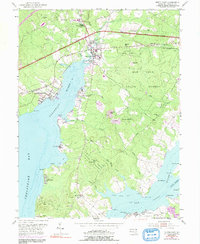
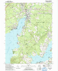
North East sits at the head of its namesake river, where the CSX Transportation railroad intersects a landscape of tidal creeks and rising hills. This coastal Maryland topography is defined by the broad reach of the Chesapeake Bay, which branches into the North East River and the Elk River. The peninsula of Elk Neck serves as a central divide, rising to summits like Bull Mountain and Black Hill while sheltering numerous coves such as Sandy Cove and Cara Cove.
Find a feature on this map
192 named features on this map. Tap any name to fly to it.
Don’t see what you’re looking for? This feature index may not catch every label — zoom into the map to look around manually.
Map Details
Date Portrayed2023
Date Published2023
PublisherU.S. Geological Survey
Map TypeTopographic
Scale1:24000
Physical Dimensions24 x 29 inches
Editions of this 2023 North East Map
This is the sole edition of this map. No revisions or reprints were ever made.
Historical Maps of Indian Falls Through Time
3 maps found
Featured Locations
Source Details
SourceU.S. Geological Survey
CopyrightPublic Domain