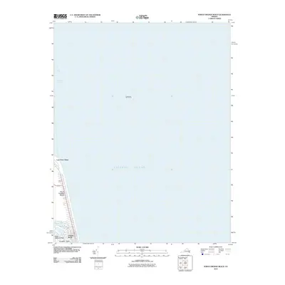
2010 Map of North Virginia Beach
USGS Topo · Published 2010About this map
Cape Henry Village and the northern residential reaches of Virginia Beach occupy the narrow coastal strip where the Atlantic Ocean meets the entrance to the Chesapeake Bay. This 2010 survey illustrates the transition from the maritime shipping lanes of the Chesapeake Bay Entrance and Cape Henry Channel to the densely developed neighborhoods of North Virginia Beach and Cavalier Park. Inland waterways like Crystal Lake and Rainey Gut punctuate the landscape, reflecting the area's intricate coastal geography. The presence of the Four H Camp and residential enclaves like North Linkhorn Park highlights the balance between community development and the prominent maritime environment of the mid-Atlantic coast at the beginning of the decade.
Find a feature on this map
13 named features on this map. Tap any name to fly to it.
Don’t see what you’re looking for? This feature index may not catch every label — zoom into the map to look around manually.
Map Details
Editions of this 2010 North Virginia Beach Map
This is the sole edition of this map. No revisions or reprints were ever made.
Other maps of this area

1893 · Virginia Beach
USGS Topo · 1:125,000

1907 · Norfolk
USGS Topo · 1:125,000

1918 · Cape Henry
USGS Topo · 1:62,500

1919 · Cape Henry
USGS Topo · 1:62,500

1943 · Richmond
USGS Topo · 1:250,000

1946 · Eastville
USGS Topo · 1:250,000

1946 · Currituck Sound
USGS Topo · 1:250,000
1948 · Virginia Beach
USGS Topo · 1:24,000
1948 · Princess Anne
USGS Topo · 1:24,000

1949 · Richmond
USGS Topo · 1:250,000