2023 Map of Oakvale
USGS Topo · Published 2023About this map
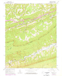
East River and the Railroad Ave corridor serve as the primary east-west artery through this rugged portion of the Appalachian Highlands. The valley floor is dotted with small settlements like Oakvale and Kellysville, where family history is anchored by sites such as the Oakvale Cem and Millirons Family Cem. The landscape is defined by massive ridges, including East River Mtn and Buckhorn Mtn, which form a natural boundary between West Virginia and Virginia. Much of the southern terrain is protected within the Jefferson National Forest, where the topography rises toward Jesses Knob and Ragged Mtn. To the south, Wolf Creek carves a parallel valley through Boxley and Phlegar, providing a more secluded corridor marked by the First Ford and historic cemeteries like Hales Chapel Cem.
Find a feature on this map
79 named features on this map. Tap any name to fly to it.
Don’t see what you’re looking for? This feature index may not catch every label — zoom into the map to look around manually.
Map Details
Editions of this 2023 Oakvale Map
This is the sole edition of this map. No revisions or reprints were ever made.