1978 Map of Ocala
USGS Topo · Published 1980About this map
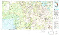
The dense forests of Gulf Hammock and the massive limestone-filtered waters of Silver Springs Run define this mid-Florida landscape during the late 1970s. This survey illustrates the contrast between the urban concentration of Ocala and the broad, wet prairies of the north, including Paynes Prairie and Kanapaha Prairie. The Seaboard Coast Line Railroad serves as a primary logistical corridor, connecting older agricultural and industrial hubs like Williston and Dunnellon. Along the western edge, the coastline transitions through the salt marshes of Waccasassa Bay and Withlacoochee Bay, where the Withlacoochee River meets the Gulf of Mexico. Significant water features such as Orange Lake and Lochloosa Lake dominate the northeastern quadrant, while Rainbow River flows south from its famous headsprings. Notable aviation infrastructure is documented at Ocala Municipal Airport and Williston Municipal Airport, reflecting the region's mid-century development and transport networks.
Find a feature on this map
116 named features on this map. Tap any name to fly to it.
Don’t see what you’re looking for? This feature index may not catch every label — zoom into the map to look around manually.
Map Details
Editions of this 1978 Ocala Map
2 editions found