1978 Map of Ocala
USGS Topo · Published 1985About this map
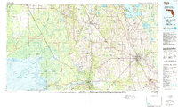
The Ocala Ridge provides the topographic backbone for this 1978 survey, which captures a landscape defined by its subterranean hydrology and Gulf Coast wetlands. To the west, the massive Gulf Hammock and Devils Hammock dominate the lowlands, where the Waccasassa River and Withlacoochee River meet the salt marshes of Waccasassa Bay. This area illustrates the transition from the upland pine forests around Williston and Bronson to the coastal habitats of Yankeetown and Inglis.
Find a feature on this map
103 named features on this map. Tap any name to fly to it.
Don’t see what you’re looking for? This feature index may not catch every label — zoom into the map to look around manually.
Map Details
Editions of this 1978 Ocala Map
2 editions found

Other maps of this area

1890 · Arredondo
USGS Topo · 1:62,500

1892 · Dunnellon
USGS Topo · 1:62,500

1892 · Arredondo
USGS Topo · 1:62,500

1893 · Panasoffkee
USGS Topo · 1:62,500

1893 · Citra
USGS Topo · 1:62,500

1894 · Dunnellon
USGS Topo · 1:62,500

1894 · Arredondo
USGS Topo · 1:62,500

1895 · Williston
USGS Topo · 1:62,500

1895 · Tsala Apopka
USGS Topo · 1:62,500

1895 · Citra
USGS Topo · 1:62,500