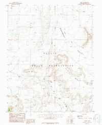
1987 Map of Oljeto
USGS Topo · Published 1987About this map
The settlement of Oljeto serves as the focal point for this 1980s landscape within the Navajo Indian Reservation. This map reveals a high-desert environment defined by massive sandstone formations, including Oljeto Mesa, Holiday Mesa, and the northern reaches of Monument Valley. Human activity is marked by more than just dwellings; the inclusion of Adits near the mesas suggests mineral exploration or mining history in the region, while a Landing Strip near the primary wash indicates the area's reliance on air transport for access. The hydrology of this arid terrain is traced through Oljeto Wash and isolated water sources like Mitchell Spring and Oljeto Spring, which were vital for life and livestock in this corner of San Juan County.
Find a feature on this map
16 named features on this map. Tap any name to fly to it.
Don’t see what you’re looking for? This feature index may not catch every label — zoom into the map to look around manually.
Map Details
Editions of this 1987 Oljeto Map
This is the sole edition of this map. No revisions or reprints were ever made.
Other maps of this area

1883 · Marsh Pass
USGS Topo · 1:250,000

1886 · Henry Mountains
USGS Topo · 1:250,000

1892 · Marsh Pass
USGS Topo · 1:250,000

1892 · Henry Mountains
USGS Topo · 1:250,000

1952 · Clay Hills 4 SW
USGS Topo · 1:24,000

1952 · Clay Hills 3 SE
USGS Topo · 1:24,000

1952 · Agathla Peak 1 NW
USGS Topo · 1:24,000

1952 · Agathla Peak 2 NW
USGS Topo · 1:24,000

1952 · Boot Mesa
USGS Topo · 1:62,500

1952 · Clay Hills 3 SW
USGS Topo · 1:24,000