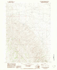
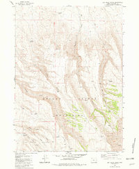
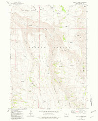
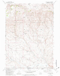
1982 Map of Oregon Canyon Ranch
USGS Topo · Published 1983About this map
Oregon Canyon Ranch and a series of family-named ranching outposts characterize this high-desert landscape in Malheur County during the late 1970s. The terrain is dominated by the steep drainages of the Oregon Canyon Mountains, where seasonal water sources like Buckaroo Spring and Poplar Spring provided essential resources for livestock in an arid environment. Named sites such as Ansotegui Place, Gavica Place, and Jaca Place reflect the regional history of Basque ranching families who established a presence in this remote corner of southeastern Oregon. The presence of an Airstrip near the main ranch complex and a series of water management features, including Schoolhouse Reservoir and several numbered springs, indicates a landscape engineered for large-scale cattle operations. Transport and movement across the canyon floor are marked by unimproved roads and utility lines, including the U G W P L and D W P, which cross the marshy flats of Oregon Canyon.
Find a feature on this map
35 named features on this map. Tap any name to fly to it.
Don’t see what you’re looking for? This feature index may not catch every label — zoom into the map to look around manually.
Map Details
Editions of this 1982 Oregon Canyon Ranch Map
This is the sole edition of this map. No revisions or reprints were ever made.
Other maps of this area

1955 · Jordan Valley
USGS Topo · 1:250,000

1955 · Adel
USGS Topo · 1:250,000

1957 · Adel
USGS Topo · 1:250,000

1957 · Jordan Valley
USGS Topo · 1:250,000

1958 · Adel
USGS Topo · 1:250,000

1958 · Jordan Valley
USGS Topo · 1:250,000

1962 · Adel
USGS Topo · 1:250,000
1981 · Dry Creek Bench
USGS Topo · 1:24,000
1981 · Doolittle Creek
USGS Topo · 1:24,000
1982 · Payne Creek
USGS Topo · 1:24,000