1981 Map of Oregon End Table
USGS Topo · Published 1982About this map
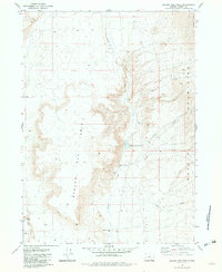
Oregon End Table rises above a landscape of high desert drainage and cattle ranching in Harney County, documented during this 1981 survey. The Oregon End Ranch and the nearby Oregon End Well suggest a working landscape where water management was critical to survival. The map traces the rugged eastern face of the Pueblo Mountains, where numerous seasonal drainages like Modesto Creek and Stonehouse Creek descend toward the basin. The presence of the Oregon End Reservoir and several named water sources, including Indian Spring and Spring Creek, highlights the importance of these rare hydrologic features for grazing and habitation in the arid Oregon interior. Remote four-wheel-drive tracks provide the primary means of traversing the high plateaus and deep draws that characterize this portion of the Great Basin.
Find a feature on this map
16 named features on this map. Tap any name to fly to it.
Don’t see what you’re looking for? This feature index may not catch every label — zoom into the map to look around manually.
Map Details
Editions of this 1981 Oregon End Table Map
This is the sole edition of this map. No revisions or reprints were ever made.
Other maps of this area

1886 · Disaster
USGS Topo · 1:250,000

1893 · Disaster
USGS Topo · 1:250,000

1954 · Vya
USGS Topo · 1:250,000

1955 · Adel
USGS Topo · 1:250,000

1957 · Adel
USGS Topo · 1:250,000

1958 · Vya
USGS Topo · 1:250,000

1958 · Adel
USGS Topo · 1:250,000

1962 · Vya
USGS Topo · 1:250,000

1962 · Adel
USGS Topo · 1:250,000
1965 · Railroad Point
USGS Topo · 1:62,500