
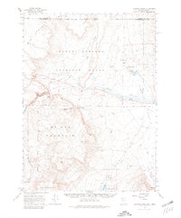
1965 Map of Railroad Point
USGS Topo · Published 1967About this map
Thousand Creek Ranch and Bog Hot Ranch anchor this high-desert landscape in the mid-1960s, located just south of the Oregon Nevada border. The map detail highlights an arid economy dependent on scattered water sources, including the geothermal Bog Hot Springs and numerous improvements like Gilliotti Well and Bog Hot Res. This area, part of the Charles Sheldon Antelope Range, is dominated by significant landforms such as McGee Mountain and the steep cuts of Thousand Creek Gorge. Evidence of local industry appears at the Painted Hills Mine, while the remote nature of the terrain is underscored by the presence of a lone Landing Strip and specialized routes like the Thousand Creek Grade (Jeep). Water remains the central theme, with drainages like Alder Creek and Sagebrush Creek defining the valley floors.
Find a feature on this map
40 named features on this map. Tap any name to fly to it.
Don’t see what you’re looking for? This feature index may not catch every label — zoom into the map to look around manually.
Map Details
Editions of this 1965 Railroad Point Map
2 editions found
Other maps of this area

1886 · Disaster
USGS Topo · 1:250,000

1889 · Long Valley
USGS Topo · 1:250,000

1893 · Disaster
USGS Topo · 1:250,000

1954 · Vya
USGS Topo · 1:250,000

1955 · Adel
USGS Topo · 1:250,000

1957 · Adel
USGS Topo · 1:250,000

1958 · Vya
USGS Topo · 1:250,000

1958 · Adel
USGS Topo · 1:250,000

1962 · Vya
USGS Topo · 1:250,000

1962 · Adel
USGS Topo · 1:250,000