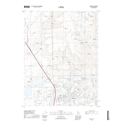
2018 Map of Oroville
USGS Topo · Published 2018About this map
The Feather River corridor and the city of Oroville dominate this late 2010s landscape, illustrating a complex network of water management and historic foothill settlements. The industrial and agricultural heritage of the region is etched into the terrain via the Thermalito Power Canal, Lower Miocene Canal, and the large Thermalito Forebay. North of the city, the dramatic geological formations of North Table Mtn and South Table Mtn rise above smaller communities like Oregon City and Thompson Flat. For local historians and genealogists, the map identifies several significant burial sites, including the Butte County Cem, Thompson Flat Cem, and Pioneer Cem. The topographic detail also captures the transition from the river valley floor to the ravines and gulches of the Sierra Nevada foothills, including Oregon Gulch and Potter Ravine.
Find a feature on this map
145 named features on this map. Tap any name to fly to it.
Don’t see what you’re looking for? This feature index may not catch every label — zoom into the map to look around manually.
Map Details
Editions of this 2018 Oroville Map
This is the sole edition of this map. No revisions or reprints were ever made.
Other maps of this area

1888 · Marysville
USGS Topo · 1:125,000

1888 · Smartsville
USGS Topo · 1:125,000

1888 · Bidwell Bar
USGS Topo · 1:125,000

1891 · Bidwell Bar
USGS Topo · 1:125,000

1891 · Chico
USGS Topo · 1:125,000

1891 · Marysville
USGS Topo · 1:125,000

1891 · Smartsville
USGS Topo · 1:125,000

1892 · Smartsville
USGS Topo · 1:125,000

1893 · Chico
USGS Topo · 1:125,000

1893 · Bidwell Bar
USGS Topo · 1:125,000