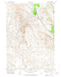
1972 Map of Osage
USGS Topo · Published 1977About this map
The Osage Oil Field dominates this 1970s landscape in Weston County, Wyoming, revealing a complex network of resource extraction and transport. Centered on the settlement of Osage, the map details the infrastructure of the era, from a dedicated Power Plant and a series of Claypits to the extensive Pipeline corridors and drilling sites that dot the terrain. The industrial footprint is balanced by a rugged drainage system defined by Poison Creek, Beaver Creek, and several named draws, such as Benhart Draw and Luce Draw.
Find a feature on this map
16 named features on this map. Tap any name to fly to it.
Don’t see what you’re looking for? This feature index may not catch every label — zoom into the map to look around manually.
Map Details
Editions of this 1972 Osage Map
This is the sole edition of this map. No revisions or reprints were ever made.
Other maps of this area

1898 · Sundance
USGS Topo · 1:125,000

1899 · Newcastle
USGS Topo · 1:125,000

1901 · Newcastle
USGS Topo · 1:125,000

1902 · Sundance
USGS Topo · 1:125,000

1918 · Moorcroft
USGS Topo · 1:125,000

1951 · Osage SE
USGS Topo · 1:24,000

1954 · Gillette
USGS Topo · 1:250,000

1955 · Newcastle
USGS Topo · 1:250,000

1955 · Gillette
USGS Topo · 1:250,000

1957 · Upton
USGS Topo · 1:62,500