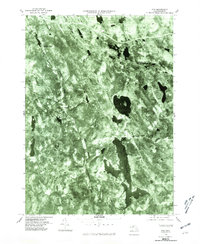
1975 Map of Otis
USGS Topo · Published 1981About this map
The Berkshire highlands are defined by water and woodland in this mid-1970s orthophotoquad, where the massive Otis Reservoir and Big Pond dominate the landscape. Unlike traditional line-drawn maps, this aerial perspective captures the dense forest cover surrounding the West Branch Farmington River as it winds through Otis. The imagery reveals the spatial relationship between small crossroads settlements like Algerie Four Corners and East Otis, highlighting how 20th-century development was constrained by the region's complex hydrology. By utilizing imagery taken in October, the map provides a clear look at the terrain's structure, from the narrow valley of North Otis to the secluded area around Cold Spring. This survey is particularly valuable for documenting the extent of shoreline development and road networks at a time when the area was firmly established as a recreational and residential retreat.
Find a feature on this map
8 named features on this map. Tap any name to fly to it.
Don’t see what you’re looking for? This feature index may not catch every label — zoom into the map to look around manually.
Map Details
Editions of this 1975 Otis Map
This is the sole edition of this map. No revisions or reprints were ever made.
Other maps of this area

1886 · Chesterfield
USGS Topo · 1:62,500

1886 · Becket
USGS Topo · 1:62,500

1887 · Granville
USGS Topo · 1:62,500

1888 · Becket
USGS Topo · 1:62,500

1888 · Sandisfield
USGS Topo · 1:62,500

1888 · Chesterfield
USGS Topo · 1:62,500

1889 · Granville
USGS Topo · 1:62,500

1893 · Granville
USGS Topo · 1:62,500

1893 · Chesterfield
USGS Topo · 1:62,500

1893 · Becket
USGS Topo · 1:62,500