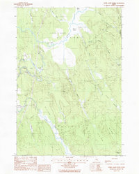
1988 Map of Otter Chain Ponds
USGS Topo · Published 1988About this map
Sunkhaze Meadows and a sprawling network of wetlands dominate this 1988 survey of central Penobscot County. The landscape is defined by the winding course of Sunkhaze Stream and the Otter Chain Ponds, which flow through a series of large boggy basins including No 16 Swamp and Island Swamp. Human settlement is minimal, concentrated primarily around the town of Bradley in the southwest and scattered dwellings along the roads near Greenfield in the northeast.
Find a feature on this map
26 named features on this map. Tap any name to fly to it.
Don’t see what you’re looking for? This feature index may not catch every label — zoom into the map to look around manually.
Map Details
Editions of this 1988 Otter Chain Ponds Map
This is the sole edition of this map. No revisions or reprints were ever made.
Other maps of this area

1902 · Orono
USGS Topo · 1:62,500

1917 · Passadumkeag
USGS Topo · 1:62,500

1929 · Great Pond
USGS Topo · 1:48,000

1931 · Saponac
USGS Topo · 1:48,000

1932 · Great Pond
USGS Topo · 1:62,500

1934 · Saponac
USGS Topo · 1:62,500

1944 · Orono
USGS Topo · 1:62,500

1946 · Orono
USGS Topo · 1:62,500

1948 · Bangor
USGS Topo · 1:250,000

1954 · Millinocket
USGS Topo · 1:250,000