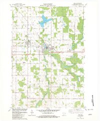
1982 Map of Owen
USGS Topo · Published 1982About this map
Withee and Owen serve as the primary hubs in this central Wisconsin landscape, where the Soo Line Railroad intersects the regional road network near the Owen-Withee High Sch. The map reveals a transition in land use, featuring an Old Railroad Grade alongside modern infrastructure like the Owen-Withee Landing Strip. To the south, the settlement of Longwood sits near the Emmanuel Ch Cem and Emmanuel Ch, marking a cluster of local history and genealogy interest.
Find a feature on this map
28 named features on this map. Tap any name to fly to it.
Don’t see what you’re looking for? This feature index may not catch every label — zoom into the map to look around manually.
Map Details
Editions of this 1982 Owen Map
This is the sole edition of this map. No revisions or reprints were ever made.
Other maps of this area

1951 · Lublin
USGS Topo · 1:48,000

1951 · Medford
USGS Topo · 1:48,000

1953 · Abbotsford
USGS Topo · 1:48,000

1953 · Owen
USGS Topo · 1:48,000

1953 · Eau Claire
USGS Topo · 1:250,000

1953 · Rice Lake
USGS Topo · 1:250,000

1958 · Eau Claire
USGS Topo · 1:250,000

1959 · Rice Lake
USGS Topo · 1:250,000

1963 · Abbotsford
USGS Topo · 1:62,500

1963 · Owen
USGS Topo · 1:62,500