
1891 Map of Oxford
USGS Topo · Published 1891About this map
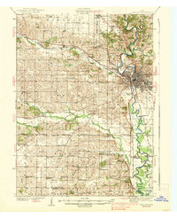
The town of Oxford serves as the primary hub for this late nineteenth-century survey, situated at the junction of the Chicago Rock Island and Pacific Railroad and the winding Hartwell Run. The landscape is defined by an intricate drainage system that shapes the local topography, featuring Old Mans Creek and its North Branch, which bisect the central townships. To the south, the North English River creates a prominent boundary, fed by smaller tributaries like Teener Creek and Miller Creek.
Find a feature on this map
20 named features on this map. Tap any name to fly to it.
Don’t see what you’re looking for? This feature index may not catch every label — zoom into the map to look around manually.
Map Details
Editions of this 1891 Oxford Map
This is the sole edition of this map. No revisions or reprints were ever made.
Other maps of this area

1887 · Cedar Rapids
USGS Topo · 1:62,500

1888 · Amana
USGS Topo · 1:62,500

1889 · Amana
USGS Topo · 1:62,500

1891 · Cedar Rapids
USGS Topo · 1:62,500

1891 · Iowa City
USGS Topo · 1:62,500

1894 · Oxford
USGS Topo · 1:62,500

1899 · Amana
USGS Topo · 1:62,500

1903 · Fairfax
USGS Topo · 1:125,000
1938 · Iowa City
USGS Topo · 1:62,500

1954 · Des Moines
USGS Topo · 1:250,000