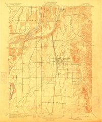
1912 Map of Palermo
USGS Topo · Published 1912About this map
Palermo and the surrounding Butte County countryside appear here during a period of significant agricultural and industrial development. The landscape is defined by the dual presence of the Southern Pacific RR and Western Pacific rail lines, which parallel each other through the center of the sheet, supporting local industry at the W P Shops. Near South Oroville, the map identifies the Chinese Cem and Oroville Cem, providing important landmarks for genealogical research. The Feather River winds along the western edge, while smaller watercourses like Wyman Ravine and Wyandotte Creek drain the terrain toward the south. Rural education is anchored by Union School and Lonetree School, marking the scattered residential clusters of Pacific Heights, Villa Verona, and Hearst before the expansion of modern orchards and infrastructure.
Find a feature on this map
21 named features on this map. Tap any name to fly to it.
Don’t see what you’re looking for? This feature index may not catch every label — zoom into the map to look around manually.
Map Details
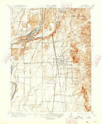
Editions of this 1912 Palermo Map
2 editions found
Other maps of this area

1888 · Marysville
USGS Topo · 1:125,000

1888 · Smartsville
USGS Topo · 1:125,000

1888 · Bidwell Bar
USGS Topo · 1:125,000

1891 · Bidwell Bar
USGS Topo · 1:125,000

1891 · Chico
USGS Topo · 1:125,000

1891 · Marysville
USGS Topo · 1:125,000

1891 · Smartsville
USGS Topo · 1:125,000

1892 · Smartsville
USGS Topo · 1:125,000

1893 · Chico
USGS Topo · 1:125,000

1893 · Bidwell Bar
USGS Topo · 1:125,000