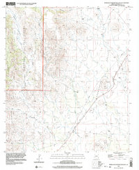
1996 Map of Pedregosa Mountains East
USGS Topo · Published 2003About this map
The Pedregosa Mountains dominate the western portion of this landscape, their high ridges dropping sharply into the wide San Bernardino Valley to the east. Within the Coronado National Forest, a network of drainage systems including Halfmoon Valley, Mulberry Canyon, and Walnut Canyon carve through the mountain terrain. This 1996 survey records a remote borderland environment defined by its water management and transit history. An Old Railroad Grade cuts a diagonal path across the valley floor, tracing a line parallel to modern infrastructure like the prominent Pipeline. Numerous Water Tanks are scattered across the arid flats of the San Bernardino Valley, marking the essential points of utility for cattle ranching or land management in this portion of Cochise County. Low-lying features like the Gravel Pit and various washes including Indian Creek further illustrate the geomorphology of the high desert basin.
Find a feature on this map
15 named features on this map. Tap any name to fly to it.
Don’t see what you’re looking for? This feature index may not catch every label — zoom into the map to look around manually.
Map Details
Editions of this 1996 Pedregosa Mountains East Map
This is the sole edition of this map. No revisions or reprints were ever made.
Other maps of this area

1917 · Chiricahua
USGS Topo · 1:125,000

1919 · Perilla
USGS Topo · 1:125,000

1919 · Chiricahua
USGS Topo · 1:125,000

1922 · McDonald
USGS Topo · 1:62,500

1926 · Pedregosa
USGS Topo · 1:62,500

1940 · Apache
USGS Topo · 1:62,500

1940 · College Peaks
USGS Topo · 1:62,500

1955 · Douglas
USGS Topo · 1:250,000

1958 · Apache
USGS Topo · 1:62,500

1958 · Guadalupe Canyon
USGS Topo · 1:62,500