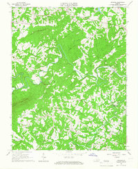
1965 Map of Penhook
USGS Topo · Published 1966About this map
Pigg River winds through the heart of this mid-century Virginia landscape, forming the natural backdrop for the rural communities of Union Hall and Penhook. The arrival of the recently created Smith Mountain Lake is visible in the northeast corner, marking a significant transition in the local geography and water management. This area is characterized by a dense network of family-centered landmarks, such as Laprades Mill and Adams Store, which served as hubs for these small agrarian settlements.
Find a feature on this map
50 named features on this map. Tap any name to fly to it.
Don’t see what you’re looking for? This feature index may not catch every label — zoom into the map to look around manually.
Map Details
Editions of this 1965 Penhook Map
2 editions found
Other maps of this area

1890 · Roanoke
USGS Topo · 1:125,000

1891 · Roanoke
USGS Topo · 1:125,000

1922 · Callands
USGS Topo · 1:48,000

1924 · Callands
USGS Topo · 1:62,500

1925 · Rocky Mount
USGS Topo · 1:48,000

1927 · Rocky Mount
USGS Topo · 1:62,500

1944 · Rocky Mount
USGS Topo · 1:62,500

1944 · Callands
USGS Topo · 1:62,500

1947 · Roanoke
USGS Topo · 1:250,000

1951 · Boones Mill
USGS Topo · 1:62,500